Sundial Park Genk

Introduction
The Sundial Park in Genk (Belgium) is a permanent sundial exhibition at an international level, presenting many different sundial types. An impressive sample of what the science of Gnomonics has created in the past centuries. What a splendid initiative!
The Sundial Park has been constructed under the auspices of the
Flemish Sundial Society (website in Dutch). Project manager was Jan De Graeve, Vice President of the Society. The official opening took place on 19 March 2000.
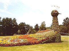 I invite you to a virtual tour through the Sundial Park. We will take the official route. Most 'real' visitors, coming from the downtown shopping area, may jump in halfway. Unfortunately, they will no longer pass by this beautifully decorated peacock. It was not a sundial, but doesn't it serve nicely as a logo for this site?
We will not take things too easily, though. Uncritical acclaim would reflect lack of interest, rather than admiration. And you won't learn anything. I appeared to learn most by a critical, detailed evaluation of what there was to see. The first aim of this tour is therefore to educate ourselves; I don't intend to go after the designer or the constructor. On the other hand, a Sundial Park at an international level should have the ambition to present top objects. Comments are in place if they fall short.
Written information available to visitors includes the information panel next to each sundial, a folder that is available from a dispenser at the parking area near the Molenpark entrance, and a brochure that can be obtained from the Tourist Office in the City Hall. All are in Dutch, so I will only occasionally refer to them. In addition, I have used the information bundle that was distributed at the international Symposium which accompanied the official start of the project, on 20 June 1998.
I hope you will enjoy the tour!
Frans W. Maes, guide
Overview
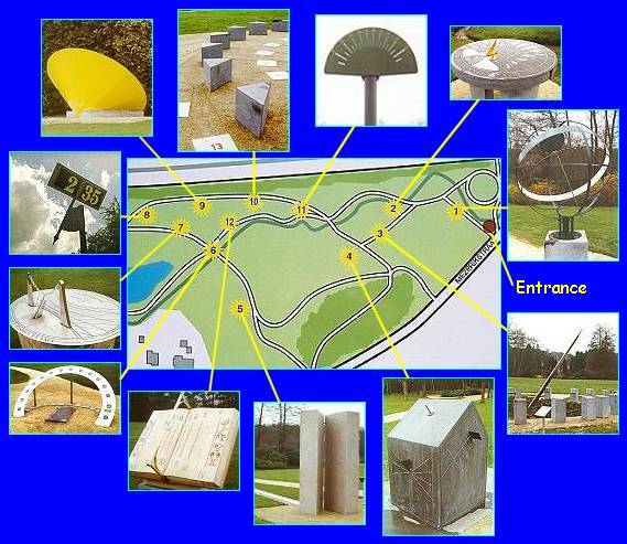
The Sundial Park takes up the eastern half of the Molenvijverpark. The little stream (the dark green winding line in the map below) feeds the Millpond, which once was the reservoir for a water mill. You may click the thumbnails in the plan below to jump to the corresponding object.
Location: 51.0° NB, 5.5° OL
<- home
next ->